Penampang folks first, not ‘Pain Borneo’
Published on: Sunday, November 28, 2021
Text Size:
Proof only one quarter of width of Moyog river was available for flood water to pass.
Jabatan Pengairan dan Saliran made a long-winded praise to the high intensity of rain recorded, but declined to answer if they had five year rainfall records for study and comparison.
Another question spilled the beans that none of the four flood mitigation projects in the district have been completed despite big promises way back in 2016. Only two were implemented but not completed.
JPS said the federal government never released all the RM481 million allocations until today.
Meanwhile the present state government recently announced that two were already completed and only one left to go, leading to a new government formula of 4 - 2 = 1. The other one presumably has gone to the pandora banks. (pun-intended)
So please explain why there is plenty of money for Pain Borneo highway which is not urgently needed by the people compared to the flood mitigation drains that stopped between the Bomba and Police station which is the main reason Donggongon town is easily flooded these days.
The Deputy Director for Pain Borneo had this to say... “the width of the river upstream, downstream and where the bridge is built is the same, we dont block the river, we only build the...(cut short)” and ended with the world famous statement, “Kami tiada buat Kesempitan sungai”.
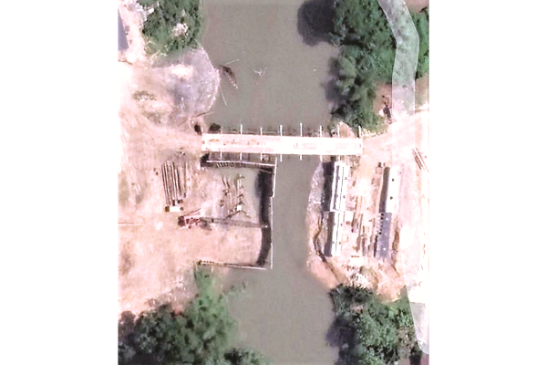
To prove his point, please publish the areal photo attached taken at Moyog One or Monsopiad Bridge location.
This section of the river is the only channel that drains the whole of Penampang plain including the Limbanak River and Sugud River that joins Moyog river just upstream of this site. The width of the river was just a quarter after both sides were filled up for a construction platform but still complies with a “luyar buruk” argument that the river was not blocked.
JPS engineers would understand the implications but they declined to answer if the construction methods in the river was approved by them.
The flood depth at Balai Raya Kg Tampasak Sugud on 15th Sept was 5 ft 8 inch from its floor level, the highest in history.
Sugud river is not crossed with a bridge, instead six box culverts were installed side by side which is not in accordance with JPS guidelines. I therefore challenge JKR “coninsultants” to show me their calculation on how much flow discharge is reduced by these culverts as compared to open channel flow.
Then on 12th Oct with only one hour of heavy rain, Donggongon was again flooded for the whole day under a hot sun from 9am onwards which was totally ridiculous. Only a blocked river can cause such thing in the absence of any other phenomena in the district.
Next, Pain Borneo filled up the only flood retention area at Kolopis without any mitigation measures such as drains and culverts to drain back the water to Moyog River. The massive hill cuttings also have no measures to minimise mud flows going into residential homes, and is now competing with a duck farm’s hill cutting at Togudon Moyog, who lost his case in court.
At another location, a box culvert was installed with outlet pouring onto private land instead of going back to the stream. It has already been reported but as usual government department dont bother to reply.
A former employee of Environment Department leaked the info that the EIA report for Pain Borneo only had a few sentences on the floods in Penampang quoting a line... “The floods in the district is not that significant”
This is good news really because here is a professional report that says there is no floods in Penampang before Pain Borneo projects appeared. No wonder the departments are keeping this report as official secret since it is grounds for the Penampang residents to sue the government for bringing the floods via this project.
All the Penampang Councillors who served under 15 years of BN rule should explain the basis of all their approval for vast development areas such as Bundusan, Lomunu, Minintod, Kibabaig and all other development without any storm drains connecting to the Moyog River, not even a wayleave provided.
Kibabaig in Kadazan means water area, a swamp, a low land area serving as the retention pond during heavy rain and floods.
Then Malaysia turns up and for 58 years these lowlands were slowly reclaimed to build grand sounding housing areas such as Country Shangrilas (cannot even pick a local name). Too bad for the house buyers who never heard of “caveat emptor”. For years they screamed, shouted and complained but definitely same people who voted for the government that approved development without drains.
Under pressure, the government finally directed JPS to build the flood mitigation drains and they have no choice but cut through higher grounds and knocked down village houses instead of being built nearer to the natural drains in the first place.
One victim was a singer whose small house was compensated with a pittance. Until today she is still hunting for a new place to stay as the small land and house was all she got. In this country, it is the poor who have to make way for the rich.
No wonder when the present MP cum Adun said the floods in Penampang is due to corruption, he was clobbered in the state assembly and asked to “Tarik Balik”. Some people really ate the chilli and deny its hot.
Drains are the easiest to construct if done first or simultaneously with development. The contractor only needs excavators to dig a big trench, install the prefab L-shape concrete walls, make some connections and backfill the back. Definitely not RM481 million as per the uncompleted packages.
The project is stalled because there are underground cables and water pipes to be modified, telecom and electric poles to relocate, existing road excavated and rebuild and even walls, gates and fences to be compensated. These extra work bloat the project cost by at least 5 times more but makes some people happy due to 10pc.
The latest proof is the ongoing Council Proposed Development Masterplan displayed for public feedback.
It shows for 58 years the council never planned any drainage at all.
After suffering thousands of floods, the Council only marked Moyog river in blue as the district drainage system. All the rest of rivulets are not located, in fact the river we called Sungai Kionggu is even marked for Heavy Industrial Zone(Red).
Between Kg Hubah, Dahab and Dungkahang along the new highway, a red zone was simply coloured to include the river right in the middle of a residential zone. Are the nearby houses allowed to be subjected to high noises and pollution of a red zone?
The answer is simple, those lands were NT lands that were sold perhaps illegally to non-natives and to make hallal the transaction, rezone the land into commercial so the land title status can be changed to CL type.
That is another reason why they asked MP/Adun to tarik balik.
Kampung Engineer,
Penampang
ADVERTISEMENT