Spectacular geosites from mighty geo-events
Published on: Sunday, April 18, 2021
By: Kan Yaw Chong
Text Size:

Glacial erosion surface on East Plateau. Note U-shaped like valley called cirque, sharp peaks and horns shaped by glacial erosion ten thousand years ago.
Mind boggling geological events makes geology very hard to understand because they go back millions of centuries and range thousands of miles.
Geological processes describe the natural forces that account for Earth’s major surface features.
Here, our interest is not planet earth.
One big surprise is tropical Mt Kinabalu was once snow-capped and its grinding movement shaved its summit bald till today.
But when Professor Tongkul gives this geological event and process a specific focus, the lost story of ancient tropical glaciers and major surface features it had crafted on the mountain suddenly comes alive and assume a new value.
And just next door to Mt Kinabalu, Professor Tongkul highlights another masterpiece – Mt Tambuyukon which showcases one of the highest emplaced oceanic crust on a single mountain in entire Southeast Asia but was crafted by a completely different geological event and process.
To ease understanding of a complex subject that haunts lots of people, Prof Tongkul is clear on his geological time scale, provides specific time period and specific locations that identify the 46 geosites representing some of the key geological processes within the aspiring Kinabalu Global GeoPark. Since some of the geosites involve main rocks, they may still be hard to interest the public.
So this week, we go for less text and let some of the most spectacular landscapes speak about the geological processes that created them.
So we go by picture to picture:
1. West Plateau – shaped by glacial erosion during the last Ice Age about 10,000 years ago. The grooves down the rock face above Panar Laban clearly shows the direction of the ice movement until this day.
2. East Plateau – also shaped by glacial erosion, producing U-Shaped or amphitheatre-like valleys called cirques and sharp peaks called horns. So Prof Tongkul introduces cirques – which began as irregularities in the mountain side that were later enlarged by frost wedging – meaning every time water freezes, it expands by nine per cent, forcing cracky rocks apart and as glaciers move, heat from friction cause basal ice to melt and this freeze and thaw action repeated over aeons loosened and plucked out a lot of rocks from the side and bottom of the glaciers which transport them away from the mountain to lands below.
That glaciers once occurred in tropical Sabah and formed a thick snow cover probably a few hundred metres deep stuns even Prof Tongkul when we start paying this rare geo event a revisit.
He said: “The glacial erosion is one of its kind since these geological features occurred in a tropical region.”
3. Kiau Gorge – Called the Minitinduk Gorge – the ancient gateway to Mt Kinabalu. Shaped by the ongoing stream erosion along a weak fault zone on ancient oceanic crust. The nearly vertical fault zone formed during the ancient accretion of the proto –South China Sea lithosphere about 85 million years ago. The Kiau Gorge is shaped by the upper Kadamaian stream as water washed away soil and rocks from its surface.
4. The ultramafic peak – This soaring rock is part of the proto-South China Sea Oceanic ancient Crust which was faulted upwards when thick rifted continental crust located at the tail end of the proto South China Sea lithosphere collided with the accreted or deep sea sediments scrapped off from top of the proto South China Sea Oceanic Crust 15 million years ago, after it subducted or dived under the Sulu Sea Oceanic Crust with relative ease, starting 85 million years ago. Remember Prof Tongkul explained in the last two special reports that it was this subduction-accretion process that created Sabah underwater and later a tectonic collision and crustal shortening that lifted Sabah above water.
The ultramafic rock body represents one of the highest emplaced oceanic crust on a single mountain peak in Southeast Asia (2,578m asl), says Prof Tongkul.
The peak is shaped by ongoing erosion on the ultramafic slab. Prof Tongkul stressed: The ultramafic rock, which originally comes from deep down the mantle, did not “intrude”, but was faulted upwards during the collision 15 million years ago. Only Mt Kinabalu ‘intruded’ when part of the rocks in the rifted continent melted under immense pressure and frictional heat after the collision and formed a huge ball of molten magma which cooled and solidified five to seven million years ago and later lifted to the surface.”
Prof Tongkul said the spectacular ultramafic peak was easily 3,000m under water. Asked how it got faulted upwards to soar 2,575m into the sky, he said: “During subduction starting 85 million years ago, the proto-South China Sea Oceanic Crust would be accreted or scrapped off or stacked on top of each other to form a composite whole that would later became Sabah or Borneo Island.
The accreted oceanic slabs would at first be gently inclined. As the accretion or formation of a composite whole of landed Sabah and Borneo by gradual accumulation progressed, the slabs would steepen. Finally when the collision occurred 15 million years ago, the slabs would stand nearly vertical, due to shortening (see graphic). Crustal shortening typically elevates terrains by thrusting one slab of crust over another. From this elevated height of Tambuyukon, it commands an unbelievable view of nearby Mt Kinabalu.
5. The triangular facets – these are morphological features produced by active fault movements. Stream erosion passing through the fault scarps create the triangular-shaped cliff face. Asked what is driving the active fault movements in Kundasang, Prof Tongkul said: “From the ongoing collision in Sabah that started 15 million years ago.”
6. KPD Cattle Ranch, Kundasang – represents a landscape produced by glacial deposit which occurred around 10,000 years ago. This landscape is characterised by the presence of granitic boulders eroded from Mt Kinabalu and transported down the mountain by moving glaciers. The glacial deposits are one of its kind since this geological feature occurs in a tropical region noted Prof Tongkul.
7. The braided stream – located near Melangkap village, represents a wide river valley where stream channels still actively shifting laterally.
8. Topi Raja (King’s Crown) – A granite boulder with pointed spikes uniquely shaped by sub surface erosion located in Kampung Melangkap, Kota Belud. But where did this granite rock come from? Prof Tongkul: “From Mt Kinabalu possibly brought down floating ice to Melangkap, got buried underground. Then powerful flushes of subsurface water after heavy rain can erode the weathered granite rock creating those sharp spikes. This is similar to the formation of the sharp spikes on limestone rocks like those in Mt Mulu, Sarawak due to subsurface erosion.”
9. Poring Hotspring – produced by underground water in contact with remnant heat from Mt Kinabalu pluton. Asked how deep is the remnant heat contact point, Prof Tongkul said: “Not sure, could be one to two kilometres.”
10. Mamut Copper Mine Pit – a reminder of mining activities in Ranau. Copper minerlization was associated with intrusion of Mt Kinabalu magma on ancients oceanic crust around 7-8 million years ago.
11. Pillow Basalt and chert – this outcrop occurred along the Baliojong River in Tandek, illustrating the upper part of an ancient oceanic crust – the proto South China Sea lithosphere. Pillow basalt is an igneous rock that form when lava erupts underwater. The rapid cooling of the lava in cold water on all sides form the pillow shaped bodies. So once again a geosite of interest and value.

Kinabalu Geopark Geology Cross Section. Note how the ultramafic slabs represented by purple color were faulted upwards vertically due to crustal shortening after tectonic collision to form Mt Tambuyukon.

Vianah Ng of Daily Express admires the 2,750m ultramafic Peak of Mt Tambuyukon faulted upwards after a tectonic collision 15 million years ago (See 4 for explanation).
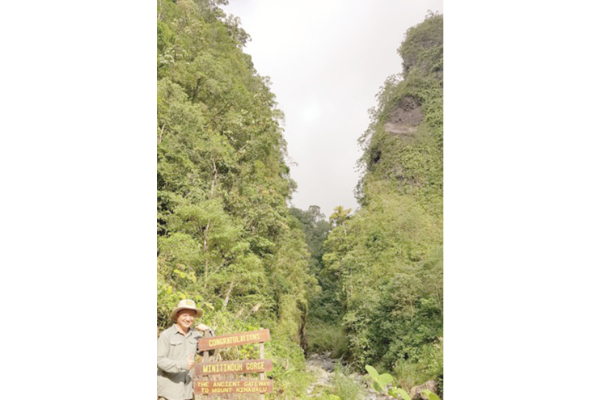
Pro Tongkul at the Minitinduk Gorge.

Spectacular view of Mt Kinabalu from the peak of Mt Tambuyukon.

Pro Tongkul

Glacial deposit landform at KPD Cattle Ranch Kundasang. Note the granitic boulders transported down by moving glaciers 10,000 years ago!

Kundasang: Produced by active fault movements which most people are not aware of.

Topi Raja in Kg Melangkap, Kota Belud.

Poring hot spring.

The former Mamut copper mine pit.

Chert and pillow basalt at Sg Baliojong, Tandek.
ADVERTISEMENT